
Felt: Cloud-Native GIS and Online Mapping Software
Felt helps organizations in sectors like agriculture, government, and transportation visualize geographic data. It is designed for teams that need to share interactive maps and spatial analysis.
At a glance
- Category
- Browse Data & Analytics tools
- Best for
- Mid-market companies, Enterprise organizations, Non-profit organizations, Educational institutions, Spatial analysts
- Pricing
- Felt offers a freemium model with a Free plan, a Team plan, and an Enterprise plan. A 7-day trial is available for Enterprise. Discounted pricing is available for non-profits and free access for education.
- Key use cases
- Agricultural Planning, Urban Mobility Analysis, Environmental Risk Assessment, Real Estate Site Selection, Insurance Claims Tracking
- Integrations
- Postgres, Snowflake, BigQuery, Amazon S3, Microsoft Azure
- Official website
- Visit Felt official website
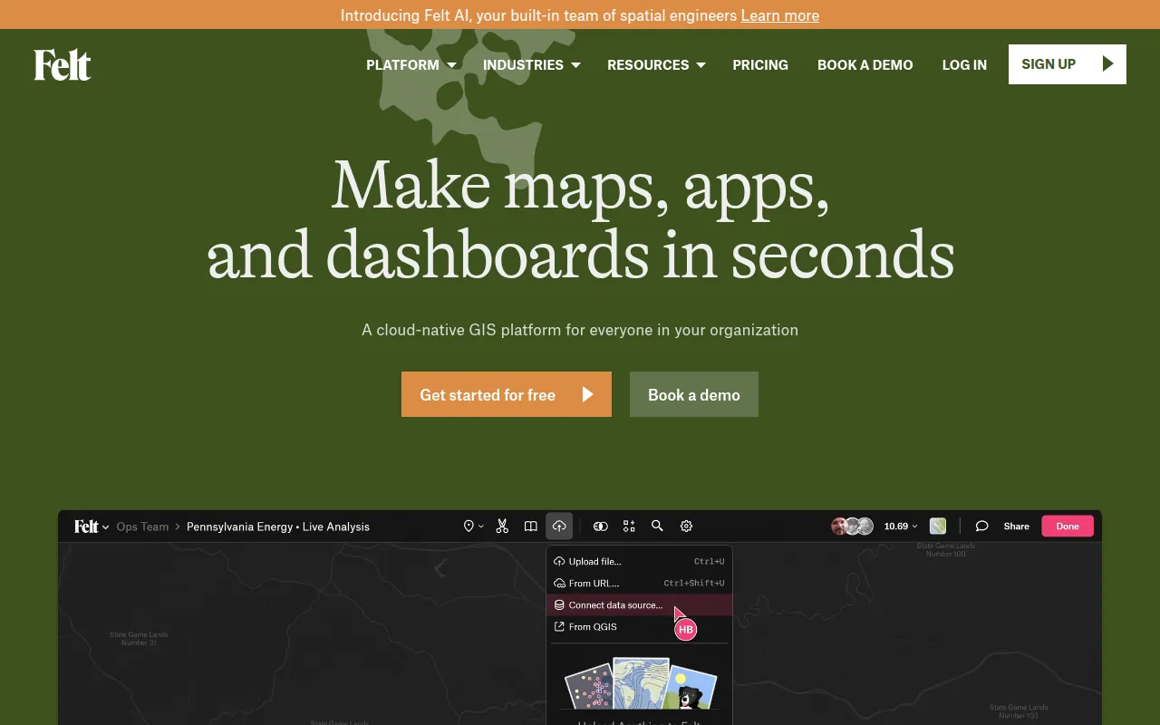
Felt is a cloud-native Geographic Information Systems (GIS) platform designed for creating interactive maps and spatial dashboards. The platform uses a browser-based approach with drag-and-drop capabilities for various file formats and automatic geocoding for addresses.
The tool supports users ranging from individual analysts to enterprise teams in industries such as real estate, energy, and climate monitoring. It supports a collaborative workflow where multiple users can work on the same canvas in real time and share results via links or embeds.
For technical teams, the platform includes a Python SDK, a JavaScript SDK, and a QGIS plugin to help in building custom spatial applications. Enterprise buyers can utilize security features such as SOC 2 Type 2 compliance and SSO/SAML support.
Buyers should confirm which plan fits their needs, as features like direct database connections and dashboard building are associated with the Enterprise tier.
Key Features
Upload Anything
Supports drag-and-drop upload of vector, raster, and spreadsheet formats with automatic geocoding.
Cloud Database Connectors
Connects to data sources including Postgres, Snowflake, BigQuery, Amazon S3, and Microsoft Azure.
Collaborative Mapping
Supports co-editing on a shared canvas in real time with link-based sharing and guest commenting.
Felt AI
Includes AI prompting capabilities designed to help users build spatial applications.
Interactive Dashboards
Supports the creation of dashboards with charts, statistics, and time-series visualizations.
Developer Tools
Provides a REST API, JavaScript SDK, and Python SDK for programmatically modifying maps.
Use Cases
Agricultural Planning
Monitoring vegetation health and tracking irrigation or equipment upgrades through field mapping.
Urban Mobility Analysis
Visualizing demand hotspots and evaluating infrastructure coverage, such as bike lane patterns.
Environmental Risk Assessment
Evaluating wildfire risk zones and monitoring deforestation patterns over time.
Real Estate Site Selection
Exploring sites for commercial or industrial development within incentive zones.
Insurance Claims Tracking
Combining parcel data with post-event imagery for insurance claims assessment.
Best For
- Mid-market companies
- Enterprise organizations
- Non-profit organizations
- Educational institutions
- Spatial analysts
Integrations
- Postgres
- Snowflake
- BigQuery
- Amazon S3
- Microsoft Azure
- QGIS
- Google Sheets
- GeoJSON export
- GeoPackage export
- GeoTIFF export
- PDF export
Pricing
Felt offers a freemium model with a Free plan, a Team plan, and an Enterprise plan. A 7-day trial is available for Enterprise. Discounted pricing is available for non-profits and free access for education.
FAQ
Who is the Felt Free plan intended for?
- The Free plan is designed for individuals who want to create and share maps for personal use.
Does Felt support professional GIS workflows?
- Yes, it provides a QGIS plugin, Python SDK, and supports formats like GeoJSON and GeoTIFF.
Which plan is required for database connections?
- Live data syncing from databases such as Postgres, Snowflake, and BigQuery is available on the Enterprise plan.
Is Felt secure for enterprise data?
- Felt is SOC 2 Type 2 and GDPR compliant, providing TLS encryption and SSO/SAML support for enterprise users.
Source category: Data & Analytics
Source subcategory: Data Visualization
More tools in Data & Analytics
Other published listings in the Data & Analytics category.
More tools tagged “Data Visualization”
Related listings that share the same software type tag.
Categories
Software Type
How AI is used
Felt is a cloud-native GIS platform for creating interactive maps, dashboards, and spatial apps. It supports teams in industries like agriculture and government to collaborate on geographic data in real time. Direct database integrations are reserved for the Enterprise plan.
Pros & Cons
Pros
- Low barrier to entry with drag-and-drop file uploads
- Real-time collaboration on a single map canvas
- SOC 2 Type 2 compliance
- Multiple export options including GeoJSON and GeoTIFF
- Free access for educational use
Cons
- Database connections and dashboard features are limited to the Enterprise plan
- The Free plan is designed for personal use
- Some advanced spatial analysis tools may require higher-tier plans