AI TOOL PROFILE
CARTO: Cloud-Native Location Intelligence and GIS Platform

- Data and Analytics
- Location Intelligence
- Mid-market companies
- Enterprise companies
- Data analysts
- Data scientists
- GIS professionals
- Developers
Pricing
CARTO offers three pricing tiers: Enterprise, Strategic, and Custom. A 14-day free trial is available.
At a glance
- Best for
- Mid-market companies, Enterprise companies, Data analysts, Data scientists, GIS professionals
- Key use cases
- Site Selection and Geomarketing, Risk and Catastrophe Modeling, Supply Chain and Logistics Optimization, Network Deployment Planning, Fraud Detection
- Integrations
- Google Cloud, AWS, Azure, Snowflake, Databricks
- Official website
- Visit cartodb official website
How AI is used
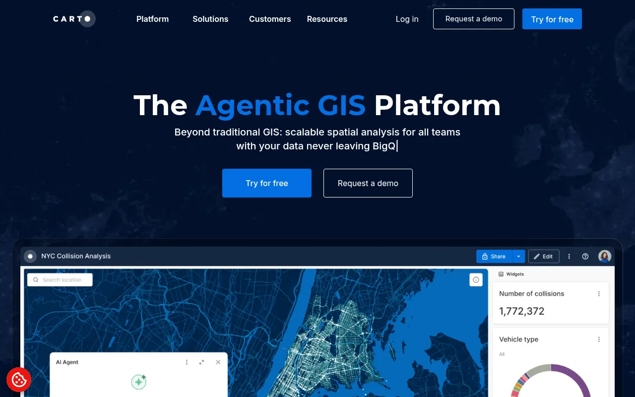
CARTO is a cloud-native GIS platform designed for organizations that handle large-scale spatial data. It provides tools for spatial analysis and visualization, including a low-code interface that helps users build maps and dashboards without complex back-end ETL processes.
The platform is designed for a range of technical users, from data analysts and GIS professionals to developers. It focuses on keeping data within the user's cloud environment, which may support better data governance and security for sensitive enterprise information.
Capabilities include AI Agents for natural language queries, an analytics toolbox for geospatial functions, and app development tools. This helps businesses create digital solutions for tasks like site selection or risk modeling.
Buyers should confirm if their technical team has the expertise to manage the platform and verify which of the three pricing tiers aligns with their organizational structure.
Key Features
Spatial Analysis Toolbox
Includes over 100 analysis components and geospatial functions with native ML and AI integrations.
Data Visualization Builder
Uses deck.gl, web-GL, and GPU technology to visualize large datasets through maps and dashboards.
AI Agents
Supports natural language queries, allowing users to ask questions about their data to receive insights.
Workflows Automation
A drag-and-drop interface designed to automate spatial analysis and deployment.
App Development
Framework-agnostic development tools that allow apps to run in a data lakehouse.
Data Observatory
Provides access to a library of over 12,000 spatial datasets for data enrichment.
Use Cases
Site Selection and Geomarketing
Analyzing location data to identify growth neighborhoods and optimize the placement of physical sites.
Risk and Catastrophe Modeling
Using hyper-local risk intelligence to support decision-making for insurance and asset management.
Supply Chain and Logistics Optimization
Applying spatial analytics to help plan mobility and enhance fleet efficiency.
Network Deployment Planning
Leveraging live insights and secure spatial data for on-demand infrastructure and network planning.
Fraud Detection
Using location intelligence to identify and analyze patterns associated with fraudulent activity.
Integrations
- Google Cloud
- AWS
- Azure
- Snowflake
- Databricks
- Oracle
FAQ
Who is CARTO designed for?
- CARTO is designed for mid-market and enterprise companies, specifically targeting data analysts, data scientists, GIS professionals, and developers.
Does CARTO offer a free trial?
- Yes, CARTO provides a free 14-day trial.
What are the different pricing tiers for CARTO?
- The platform offers three tiers: Enterprise for business unit implementation, Strategic for multi-departmental teams, and Custom for large enterprises.
Can non-technical users get insights from CARTO?
- Yes, CARTO includes AI Agents that allow users to interact with maps and dashboards using natural language queries.
Source category: Data & Analytics
Source subcategory: Location Intelligence
More tools in Data & Analytics
Other published listings in the Data & Analytics category.
More tools in the Location Intelligence software type
Related listings that share the same software type for comparison and shortlisting.